
Four Typhoons at Once: The Extraordinary Satellite Image of November 2024. There are photographs of storms.
And then there are photographs that change the way we understand the planet.
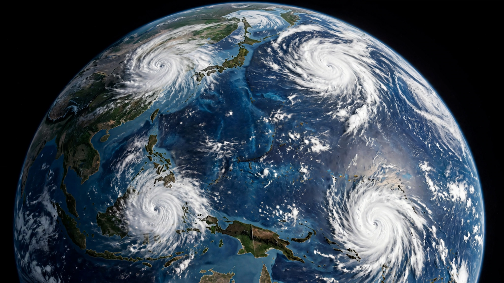
On November 11, 2024, NASA’s DSCOVR spacecraft looked back toward Earth from approximately 1.5 million kilometres away and captured an extraordinary scene over the western Pacific.
Four tropical cyclones occupied the same ocean basin at the same time:
Yinxing, Toraji, Usagi and Man-yi.
From orbit, they appeared as four pale spirals against an enormous blue ocean.
The image was beautiful.
The reality beneath it was not.
The Philippines was being struck by another storm after an already punishing sequence of tropical cyclones, while additional systems were strengthening offshore.
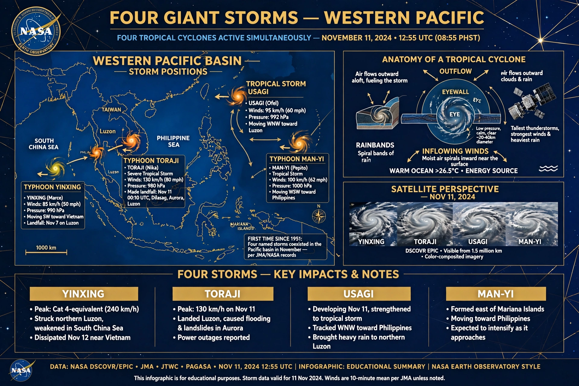
And according to the Japan Meteorological Agency, the November 2024 configuration set a record: four tropical cyclones co-existing in the Pacific basin during November, something not observed in the agency’s records dating back to 1951.
The photograph is memorable because of the number four.
The science behind it is much more interesting.
Table of Contents
Four Typhoons at Once: A Camera Looking Back at Earth
The spacecraft responsible for the photograph was DSCOVR—the Deep Space Climate Observatory.
Its location is unusual for an Earth-observing spacecraft.
DSCOVR operates near the Sun-Earth L1 Lagrange point, roughly 1.5 million kilometres from our planet. From there, its EPIC camera can observe the sunlit side of Earth as a whole rather than concentrating on a single region.
That enormous distance changes the visual scale completely.
A storm that would dominate a weather map becomes a small spiral.
A coastline becomes a thin line.
An entire ocean becomes one continuous surface.
At 8:55 a.m. Philippine Standard Time on November 11, EPIC captured the four systems together. NASA Earth Observatory later published the image as its Image of the Day.
But the four storms were not four copies of the same phenomenon.
Each was telling a different story.
Four Storms, Four Different Moments
Yinxing: The Storm That Was Leaving
Yinxing, known locally in the Philippines as Marce, had already passed through northern Luzon several days earlier.
The storm reached super-typhoon strength before crossing the region on November 7.
By the time DSCOVR photographed it four days later, Yinxing was weakening and moving toward Vietnam.
Its appearance in the photograph therefore represents the final part of its life rather than its peak.
This is an important reminder about satellite imagery.
A weather photograph can make every storm appear equally important.
Meteorologists know that they may actually be at completely different stages.
Toraji: The Storm Crossing Luzon
Toraji, locally called Nika, was the most immediate concern.
It made landfall in northeastern Luzon approximately 40 minutes before DSCOVR took the photograph.
Its maximum intensity had occurred the previous night, when it reached typhoon strength.
While the satellite was photographing four storms from above, people below were dealing with flooding, rainfall and landslides.
The contrast is striking:
one image, two completely different scales of experience.
To the spacecraft, Toraji was a small spiral.
To communities underneath it, the storm was an immediate physical reality.
Usagi: Still Gathering Strength
Farther east, Usagi, or Ofel, was developing over the Pacific.
Unlike Yinxing, which was fading, Usagi was moving toward its strongest phase.
Climate Central reported that Usagi later reached maximum sustained winds of approximately 241 km/h on November 13.
That means the photograph caught Usagi before its peak.
The same frame therefore contained one weakening system, one making landfall and another intensifying.
Man-yi: The Storm With More to Come
Then there was Man-yi, known locally as Pepito.
At the moment of the photograph, Man-yi had not yet reached its eventual maximum intensity.
According to the Japan Meteorological Agency’s annual report, Man-yi became a typhoon on November 15 and reached peak intensity on November 16, with maximum sustained winds of 105 knots and a central pressure of 920 hPa.
This makes the image particularly fascinating.
The satellite was not photographing four finished storms.
It was photographing four different points on four different timelines.
One was weakening.
One was crossing land.
One was strengthening.
One had not yet reached its peak.
The photograph froze all four moments together.
What Creates a Crowd of Tropical Cyclones?
A satellite photograph shows the result.
It does not show the machinery that produced it.
Tropical cyclones require several ingredients to come together.
Among the most important are:
- sufficiently warm ocean water,
- moisture in the lower and middle atmosphere,
- atmospheric instability,
- a pre-existing disturbance,
- enough rotation from Earth’s Coriolis effect,
- and relatively weak vertical wind shear.
Warm water provides energy, but it is only one piece of the puzzle.
A storm also needs an atmosphere capable of allowing thunderstorms to organize rather than being repeatedly torn apart by changing winds at different altitudes.
When those conditions become favorable over a broad region, several disturbances can develop during the same period.
That is the basic reason an ocean basin can suddenly appear crowded with tropical systems.
The Invisible Weather Beneath the Visible Storms
The four spirals were only the most visible part of the atmospheric story.
Large-scale tropical waves can influence where and when thunderstorms become organized.
One of the best-known is the Madden-Julian Oscillation, or MJO.
The MJO is a moving pulse of enhanced and suppressed tropical convection that travels around the equatorial regions over a period measured in weeks.
When its active phase moves into a favorable region, it can alter atmospheric conditions in ways that influence tropical cyclone development.
Other equatorial waves can contribute as well.
These phenomena cannot be seen simply by looking at the photograph.
Yet they can help determine whether the atmosphere is hostile to storms or unusually receptive to them.
That is one reason modern meteorology goes far beyond watching cloud shapes.
Scientists study the invisible environment surrounding the clouds.
Why Does This Happen? The Physics Bloggers Never Explain
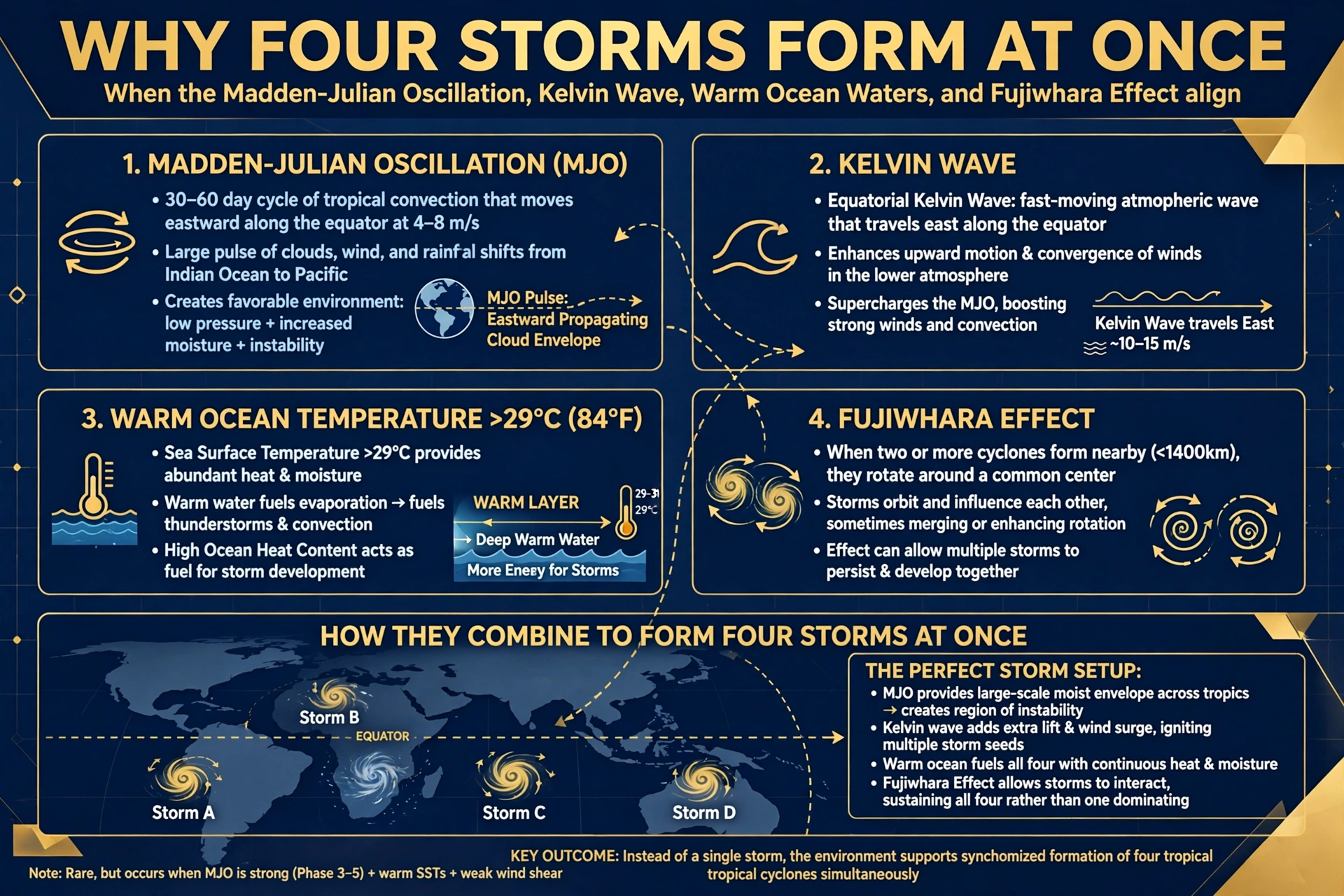
News says “warm ocean.” That’s commodity content. Here’s the non-commodity explanation:
The Fujiwhara Effect That Didn’t Happen: When storms get within ∼1400 km, they start to orbit each other. With four storms, the atmosphere becomes a pinball machine. In November 2024, they were just far enough apart to avoid merging, but close enough to steer each other toward the Philippines.
The MJO + Kelvin Wave Duo: Two invisible waves control hurricane birth. The Madden-Julian Oscillation (MJO) is a 30-60 day pulse of thunderstorms circling the tropics. A Kelvin wave is a fast atmospheric wave. In Aug 2021 and Nov 2024, both were in phase over the Pacific — like two DJs dropping the bass at the same time.
The Climate Shift Index: Climate Central analysis of the 2024 event found sea surface temperatures were made up to 40x more likely by human-caused climate change. Super Typhoon Man-yi intensified over water 29-30°C in November. Water that should be cooling.
Why the Philippine Islands Were Particularly Vulnerable
The location of the storms mattered as much as their strength.
The Philippines sits in one of the world’s most frequently affected tropical-cyclone regions.
Its geography also creates additional hazards.
Heavy rain can trigger flash floods and landslides.
Mountainous terrain can intensify rainfall impacts.
Coastal communities can face dangerous waves and storm surge.
And when storms arrive one after another, recovery becomes much harder.
Climate Central reported that the Philippines experienced 16 tropical cyclones or their remnants during 2024, contributing to severe impacts across the country.
That context changes the meaning of the satellite image.
Four spirals may look like four isolated objects.
On the ground, their effects can overlap in time.
It’s Not The First Time — A Short History of 4-Storm Parades
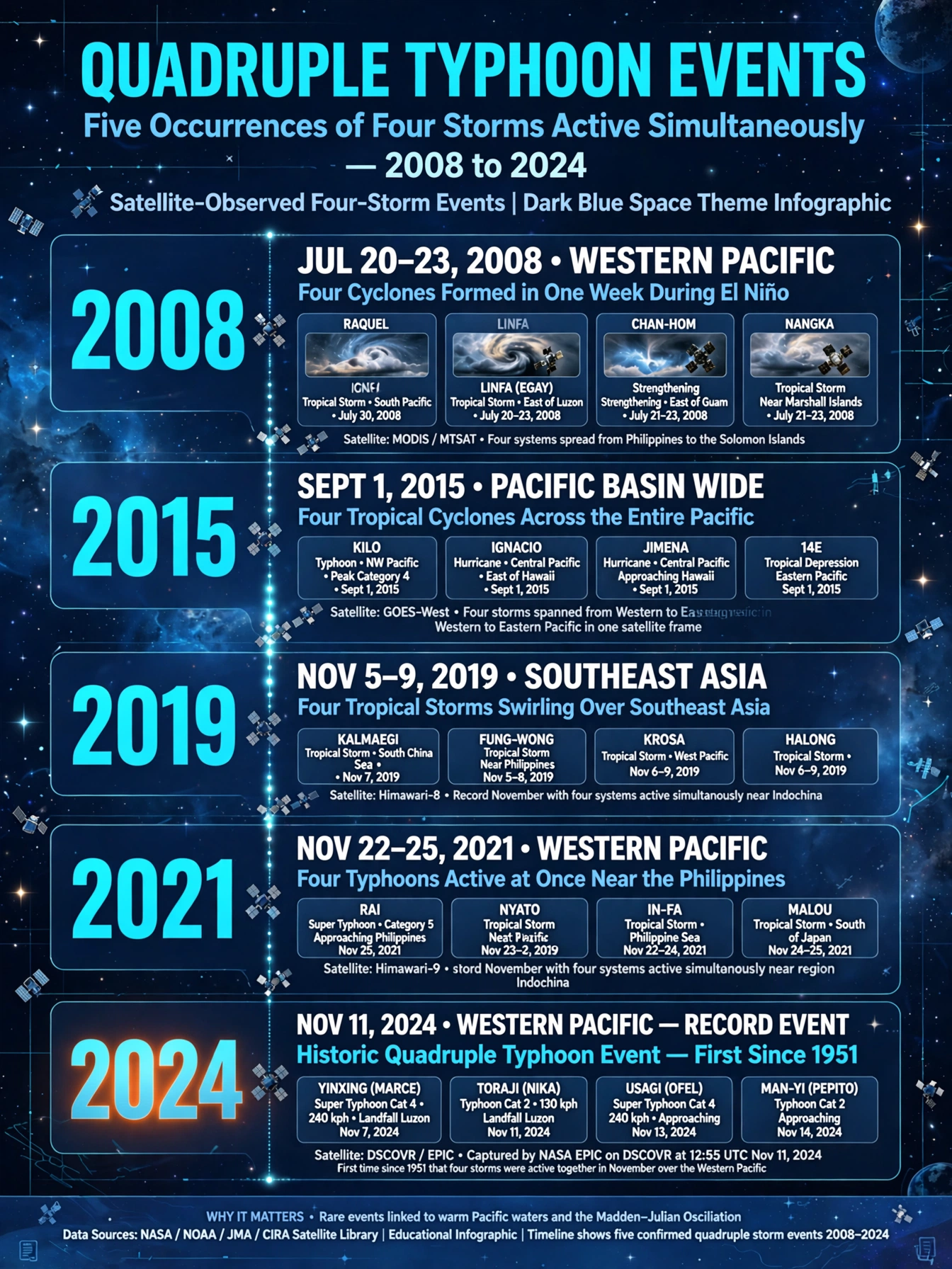
This wasn’t Earth’s first quadruple storm photo. It’s a pattern that’s getting more common.
Sept 3, 2008: The Classic
GOES saw Tropical Storm Josephine off Africa, Hurricane Ike, Tropical Storm Hanna over Bahamas, Tropical Depression Gustav over Arkansas, and Depression Karina off Baja — five systems, four named.
Sept 1, 2015: Pacific Four
GOES-West captured Typhoon Kilo, Hurricane Ignacio, Hurricane Jimena and TD 14E all in one Pacific sweep.
Sept 4, 2019: The Atlantic + Pacific Chain
NOAA’s GOES-16 captured Hurricane Dorian (Category 5, devastated Bahamas), Tropical Storm Fernand (Mexico), Tropical Storm Gabrielle, and Hurricane Juliette — a loose chain stretching across half the planet. Data via Advanced Baseline Imager.
Aug 18, 2021: North America Surrounded
GOES-16 caught Hurricane Grace (Haiti + Yucatan), Tropical Storm Fred, Tropical Storm Henri (Bahamas), and Hurricane Linda (Pacific) plus California wildfire smoke in one frame. NASA said Madden-Julian Oscillation and Kelvin waves made conditions “especially favorable”.
What makes 2024 different? All four in one basin, in November — outside peak season. That’s the historical first.
Why DSCOVR’s Perspective Is So Different
A conventional weather satellite and DSCOVR can observe the same planet while telling very different stories.
A geostationary satellite can remain focused on a particular region and collect frequent, highly detailed imagery.
That makes it extremely useful for monitoring a storm’s evolution.
DSCOVR’s EPIC camera offers something else:
context.
It can place enormous weather systems inside the wider geography of the planet.
That makes the November 2024 image visually powerful.
Instead of looking at one hurricane and asking:
How strong is it?
you can look at the whole scene and ask:
What is happening across this ocean?
That is a different scientific question.
The Beauty of the Image Is Also Its Trap
There is something unsettling about seeing destructive weather from this distance.
The storms look orderly.
Almost elegant.
Their cloud bands curve in delicate white arcs.
The ocean beneath them looks calm.
Nothing in the photograph communicates the physical experience of being underneath one.
No wind reaches the viewer.
No rain hits the camera.
No flooded roads are visible.
No evacuation sirens can be heard.
The image strips away the human scale of the disaster and leaves behind pure atmospheric structure.
That is precisely why it is so compelling.
It allows us to see something normally too large to see.
But it also reminds us that beauty and danger can occupy the same frame.
The Pacific Was Not Showing Four Identical Storms
One important detail is easy to miss when looking at the spectacular image.
Calling them “four giant hurricanes” is visually understandable, but scientifically imprecise.
The four systems were different:
| Storm | Region | Status around Sept. 27 | What made it notable |
|---|---|---|---|
| Nolo | Central Pacific | Hurricane | Powerful system near Hawaii |
| Polo | Eastern Pacific | Hurricane | Extremely rapid intensification; previously Category 5 |
| Odalys | Eastern Pacific | Weakening hurricane/tropical system | Had recently been much stronger |
| Surigae | Western Pacific | Typhoon | Powerful western-Pacific cyclone |
The terminology changes with geography.
A tropical cyclone is generally called a hurricane in the eastern and central Pacific and Atlantic, while the same type of atmospheric system is called a typhoon in the western Pacific.
So Surigae wasn’t a fundamentally different type of storm.
It was the same broad phenomenon operating in a different part of the Pacific.
The Pacific Disaster Center’s September 27 snapshot placed all four systems in the wider Pacific at the same time, while NOAA satellite products independently tracked the systems.
The situation changed quickly after the September 27 image.
- Polo weakened before making landfall in Baja California Sur on September 29 as a Category 2 hurricane, bringing dangerous winds and flooding potential.
- Nolo continued moving away from Hawaii after bringing heavy rain, high surf and flooding concerns.
- Odalys rapidly weakened and lost its tropical characteristics.
- Surigae remained a major western-Pacific system before subsequently weakening. NOAA continued monitoring it with satellite observations.
So the remarkable four-storm configuration was temporary.
That is exactly what makes satellite imagery so valuable: it preserves a moment that Earth’s atmosphere itself has already moved beyond.
The Takeaway: Abandoned Houses in the Sky
We talk about space for galaxies. But the most alien view is Earth itself when it’s angry.
Four storms at once isn’t beautiful. It’s a system overloaded. The Philippines saw 16 cyclones in 2024 alone, with 160+ deaths and 9 million displaced.
The next time GOES and DSCOVR line up four spirals, it won’t be a record. It will be a pattern.
The Pacific’s atmosphere is only one part of the bigger story unfolding above Earth. Satellites and spacecraft are giving scientists an increasingly detailed view of our planet and the wider universe.
For another look at how space technology helps us understand events on Earth, read our article on NASA’s Crew-13 mission. You can also explore the story behind SpaceX’s launch of NASA’s Roman Space Telescope, or look farther into the solar system with our article about Saturn’s mysterious 10-sided shape.
References
FAQs
Were all four storms hurricanes?
No. They were tropical cyclones at different stages and in different basins. Nolo and Polo were hurricanes, Odalys was weakening, and Surigae was a typhoon in the western Pacific.
Were the four storms close together?
No. They were spread across the enormous Pacific Ocean. The image makes them appear visually connected, but they were separated by vast distances.
Why were there so many storms in the Pacific in September 2026?
A major factor was the broader Pacific atmospheric and oceanic environment associated with El Niño, which generally favors increased tropical cyclone activity in the eastern and central Pacific. However, individual storms such as Polo cannot be attributed to El Niño alone.
Has something like this happened before?
Yes. One of the most famous examples occurred in August 2015, when Kilo, Ignacio and Jimena became three simultaneous Category 4 hurricanes across the central and eastern Pacific.
Why are satellite images important for hurricane science?
Satellites allow scientists and forecasters to monitor storm structure, temperature, moisture, movement and intensity across enormous ocean areas where direct observations are limited. Different sensors provide complementary information about the atmosphere and ocean.